|
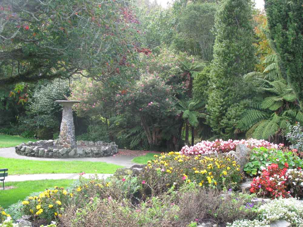
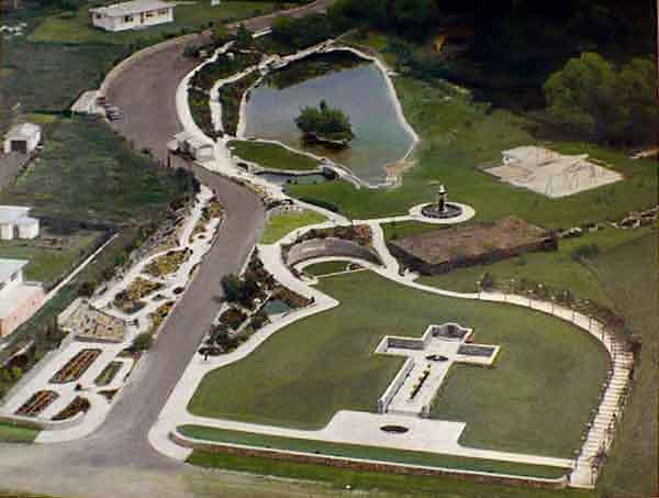
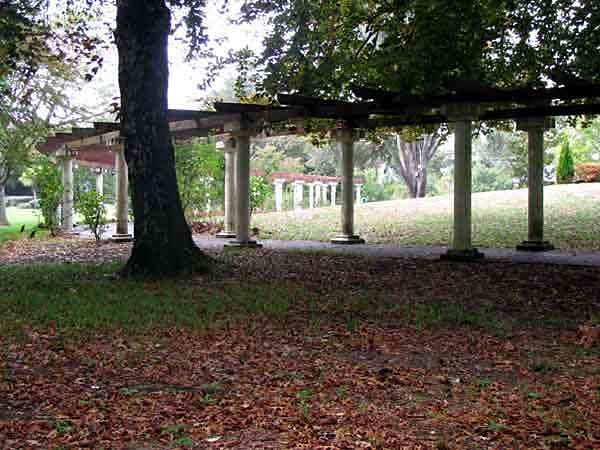
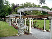
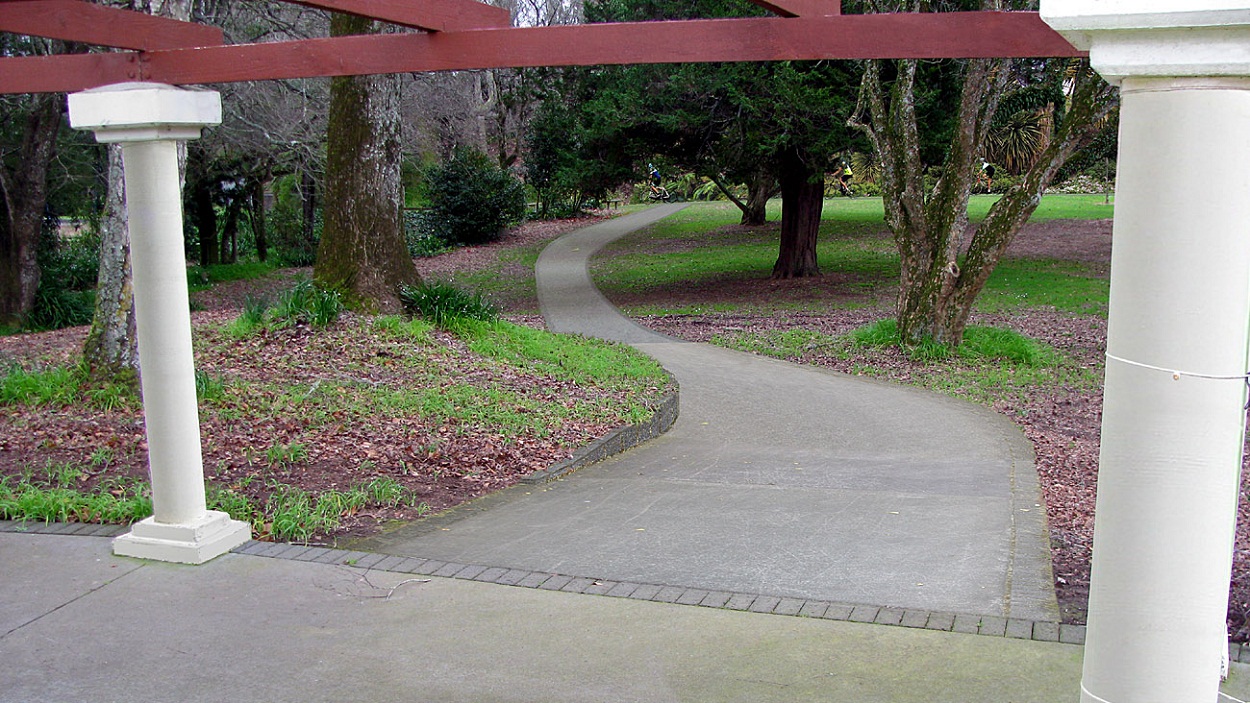
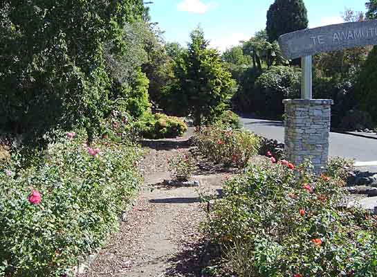
Memorial Pergola/Colonnade with a Mobility Extension Path.
The Memorial Pergola should be protected and maintained.
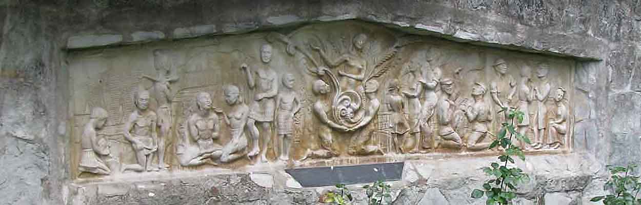
The Pergola curves around the mound in which the Sunken Cross is set, to dignify it. It leads to the Semi-Sunken Garden's Historic Mural depicting the "Ways of Life" that those named in the Cross died for.
The Columned Pergola is arguably the most attractive landscaped feature in the park.
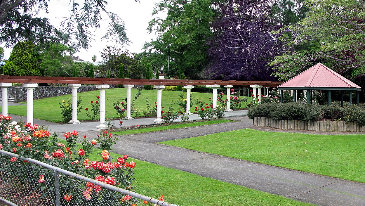
It is clear that by memorial design, climbing roses are to be growing at the Foot of Each Collumn.
See 20 Aug’ 51. “The memorial (cross) would have to have appropriate surroundings and between it and the flat land on its left a curving pergola covered with climbing roses and wisteria was suggested” But it was climbing roses alone that persisred as suitable and practical.
See 7 Nov’ 52. H.G Babbage: (Due to a shortfall in funds) “We want the actual Memorial Cross to be in a quiet and dignified area in keeping with its purpose. The pergola, originally estimated to cost 1500 pounds, will not now be erected, although it was a most attractive feature.” Fortunately funds were found.
See 28 Jan’ 55. The Pergola was nearly complete, held up by: “non-arrival of timber for the cross pieces” The roses beating them to it, nearly at the top of the columns. It was completed by May ’55.
Some original roses may still remain. Some names are of a memorial nature: Golden Jubilee, Handel, Lopen Hagen, Casino, Sympathy, New Day, New Dawn, Dublin Bay, Ice Berg.
The amended plan persists in misappropriating the Memorial Pergola as a Gateway to Maori Culture.
A Maori Culture Gateway is proposed at the Pergola's Mutu Street entrance with traffic hindering road restrictions planned for Mutu Street.
By memorial design, gates by function or form were considered a failure and were not to be featured in the memorial.
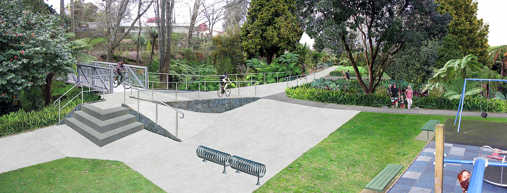
The May '20 proposal was to use the Pergola for a bike track and to demolish the curved half of it.
Following submissions the entire Pergola is to remain, without cycling through it. However, a Mobility Pathway is planned to branch off the Pergola to go through (destroying) the Sunken Fernery and to also needlessly displace (destroy) the Original Playground.
Preferable to this and more affordable, is a new embellisment; A Shared Heritage Pathway along the south side of the Mangaohoi Stream going directly to the new Airforce Footbridge. The planned Mobility Path off the Pergola can instead go around the Sunken Fernery and Playground to access the new Airforce Footbridge.
|
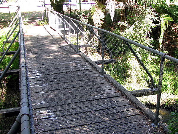
The Curved Section of the Pergola Colonnade Covered with Climbing Roses.
Dignifying the mound in which the Sunken Cross is set.
The Memorial Pergola Intact.
Not Re-Purposed as a Maori Gateway to Culture and No Bikes.
|
|
An appropriate proposal for the pergola would be to enhance it according to H Babbages original plan.
Memorial Archways in the Columned Pergola. The significance and symbolism of the Sunken Cross’ surrounds are further revealed.
See 3 Nov’ 52 “Our deficiency...will mean the abandonment of the Pergola with its three memorial arches”
See 20 Oct’ 52. “Much of the park and many of the memorial (cross) surrounds would have to be left undone...archways in the pergola, and much in the general layout scheme were to commemorate engagements in which our servicemen took part.”
“I feel that between now and the closing date...it will not be necessary to curtail our Memorial or any of its features”
Harrold G. Babbage’s Commemorative Archways over the Columned Pergola.
See three photo items “Commemorative Archways over the Colonnade.” It would be fitting that the archways could yet be established along the Columned Pergola, bearing details of engagements and theatres of war in which our servicemen took part.
Belatedly building the little known, yet much desired Commemorative Archways to the Columned Pergola would greatly “Strengthening the reserve design and historic identity” of our War Memorial Park.
Thus, as with the sunken gardens, the Columned Pergola not only assists with the dignity of the area surrounding the Sunken Cross, it is also intended to further acknowledge their sacrifice by commemorating the theatres of war they served in for our ‘Ways of Life’ depicted in the Semi-Sunken Garden, and who “even in a memorial, continue to serve ensuring comfort and Peace.”
Keith Burgess who was a Memorial Park Committee member would have been familiar with the commemorative Archways. In 2001-2 he was involved in a project to place entry arches at the front and rear of the park. The stone cladding and cement theme of the park was adopted for the style of those Entry Arches.
|
A Pergola Embellishment for Pedestrian and Mobility Access.
Branching off from the bend of the Memorial Pergola, a Memorial Maintenance Committee endorsed Mobilty Pathway Embellishment that traverses Woodland Islands of Bulb and Wild Flowers to the proposed Shared Heritage Pathway and onward to the new Airforce Footbridge.
The Pergola 'Mobility Path Extension' Retains Character, Accessibility and Existing Memorial Features of Our WW2 Memorial Park.
A Rational and Affordable Alternative to council's plan to “create an off-shoot pathway that will connect through the Fernery” to a new Play Space and Pavilion Function Space. This would destroy the Sunken Fernery and its Ornamental Stream along with the current Original Playground.
A new playground replacement costing $400.000 and 'remediation and development' (destruction) of the Sunken Fernery costing $125-$250,000, is not required with this Pergola Mobility Path Extension that simply traverses off the Pergola around the Sunken Fernery to connect to the Airforce Footbridge.
You may recall council's loaded submission form referring to 'Restoration' of the Sunken Fernery. Folk who indicated such support will be expecting an actual restoration.
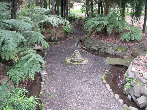
Meander through the Dappled Light of the planned 'Woodland Island' (bulbs and wild flower planting) alongside the Sunken Fernery and the Ornamental Stream.
This embellishment avoids needless destruction of Memorial Features: the Sunken Fernery, its Ornamental Stream and the Original Playgrond.
|
Scent Garden Re-Location. Established by the Te Awamutu Floral Floral Art Group in 1990
The re-location of the Scent Garden away from the road enables better Enjoyment of Quiet and Privacy. The garden structure is a popular destination for many.
The re-location enables a better view into the Park, of the Mound in which the Sunken Cross is Set and of the Columned Pergola.
As the Gazebo can be entered from either inside the Pergola or by a path alongside it, the Pergola and Gazebo are Mutually Enhanced.
The remaining space enables a path extension for the three abreast RSA Dawn Parade Marching Manoeuvre to extend past the Sunken Cross and straight ahead beyond the Pergola.
The resulting path extension, otherwise used for Pedestrian and Mobility access, connects to the Entry Arch of the Shared Heritage Pathway.
The Inviting Wide Open View from Anzac Parade.
|
'Anzac Parade Cycle Section'
Retaining Character, Accessibility and Existing Features of Our WW2 Memorial Park.
A Rational and Affordable Alternative to council's plan; to reduce the Scenic Driveway access to a congestion inducing 'One-Way' with a cycle track along it, costing $100,000 (Not Required) and for the Stone Wall to be extended along Mutu St; costing $60,000. (Not Required)
Part of G Gibb's 1947 plan for Waipa District's Memorial for WW2 was for the RSA to re-name the section of Mutu Street that fronts the Park. This embellishment aligns with council's stated objective to 'improve access' and with public submissions protesting to 'Retain Memorial Features' and the 13.8.19 Community Board Consultation; "need to keep its character and using the venue as a place of reflection"
An extension of the Pioneer Walk Cycle-Way along 'Anzac Parade' continues stream-side to meet the proposed Shared Heritage Entry Arch and Cycleway.
Accessibility of the Memorial Park via the congestion relieving Two-Way Scenic Drive is fully retained for the 'Shortest Time and Distance' travel options of Electric Cars, or for any vehicle including bikes if desired, as per the road code.
A Hedged Rest Area enables a site for a Contemporary Memorial Feature suggested in counil's plan, with Picnic Seating, to acknowledge War Service Subsequent to WW2.
A Pedestrian Crossing connects to the Memorial Pergola's Pedestrian / Mobility Extension Path.
An Additional Parking Lot provides Electric Car Charging Stations.
Two stretches of Parallel Parking opposite the parking lots are also provided.
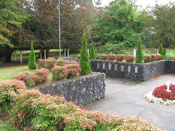
There is No Stone Wall Extension. The Stone Wall Symmetrically spans the mound in which the Sunken Cross is set by Memorial Design instead of gates, in front of the Cross, or anywhere else in the Park, as gates were considered a Memorial Failure.
In council's plan the front area including the Stone Wall and recent Scent Garden are referred to as 'protected' (from re-purposing)
Extending the Stone Wall that eventuated as a feature of the Sunken Cross, does not protect its Memorial Design or embellish the wide open area.
The view of the sports area beyond the street frontage's low maintenance planting remains Clear, Open and Inviting to all as per the Memorial Design Philosophy. However the hedged area pictured could instead be bordered by stone battered walls, in keeping with the stonework of Memorial park.
|
The Stone Wall Symmetrically Spans the Mound in which the Sunken Cross is Set.
Extending it will not enhance the adjacent wide open area.
Memorial Design Protected. No Stone Wall Extension.
Note: the Sunken Cross’ contiguous connection with the Semi-Sunken Garden’s ‘Ways of Life’ fought for, with the Sunken Lily Pond and Sunken Fernery either side.
|
Scroll the Image Below L - R.
The 'Anzac Parade Cycle Section' Retaining the Character, Accessibility and Existing Features of Our WW2 Memorial Park.
|
|
Shared Heritage Pathway for Cycling, Pedestrian and Mobility Access.
A Third Formal Front Entry for Waipa District War Memorial Park.
There is wide open space for a new Shared Heritage Entry Arch-Way amongst the planned Riparian Planting strip, that does not Re-Purpose the Pergola Colonnade.
The Sports Area north of the Pergola was intended for sports activity such as cycling that could now be enabled through the park.
Note: Only on the two new Footbridges themselves would Pedestrians within the Park actually Share with Bikes.
A Shaded Walk crossing Memorial Footbridges through the Park as proposed by G A Gibbs 12.9.47.
An Entry Arch-Way to Maori Heritage with a Shared Heritage Cycle/Pedestrian Path along the south side of the Mangaohoi Stream leading through the planned Riparian Planting directly to the new 'Contact' Airforce Footbridge. The iconography on the Arch-Way is the imagery of 'Peace and Reconciliation' by Yvonne Rust from the Semi-Sunken Garden's Historic Mural.
The Pioneer Walk is a recognition of those very same Pioneers of the Waipa District.
This Shared Heritage Path-Way enables the Two-Way Scenic Drive-Way, Columned-Pergola, Sunken Fernery and the Playground to remain in their intended Memorial State.
Following the Mangaohoi Stream to Kaipaka Park, the Shared Path crosses at the new 'Contact' Airforce Footbridge, then through the Secondary Picnic Playground behind the Oak Trees, then over the 'Kiwi' Army Footbridge to follow the Mangaohoi Stream to the confluence with the Mangapiko Stream, then arriving at Kaipaka Park.
Ko te pukapuka o te reta a Mangahoe ki nga kapua e maumahara ana ki konei. He tino tawhito te whaarangi, penei i te rau maroke ka ngaro te whaarangi.
Whakatika a Mangahoe, Ka waka ahau eke ki runga ki a koe, te mohio kei te koa koe, i te wa i whakaritea ai ti pouri.

Traffic hindering restrictions on the road in front of the entry should not be required, as traffic already moves slow nearer the Ohaupo Rd intersection.
|
A Shared Ramp for the 'Contact' Footbridge Commemorating the Service and Sacrifice of Waipa Districts WW2 Air Force Servicemen.
The Stream side Shared Heritage Pathway crosses the Mangaohoi Stream to the Picnic Area donated for the Government Approved Memorial as proposed by Geoff Gibbs.
The Shared Footbridge has a Shared Ramp featuring three steps up to a 0.7 Metre high landing that is shared with a 6:1 ramp for pedestrian and various mobility options. The landing has a baffled access to the Footbridge from behind the Main Ramp's guard rail.
The curved entry perimeter for the Main Ramp has a 4M radius from a point 1.5M along from the 2.5M footbridge entry. This enables a 3.7M wide ramp that reduces to 3M upon connecting to the Shared Heritage Path.
The Main Ramp is less than 12:1 steep with ground level raised 0.3M at its low end that includes a sloped Ornamental Stream crossing.
Within the Image.
A Bronze Commemoration Plaque is set within the footbridge side railing. Stone Battery clad Ramp Walls as per Memorial Design.
Native planting and Stone Repairs for the Sunken Fernery with large leaning trees removed. ‘Hen and Chicken’ Fern replaces Agapantha.
A Mobilty Path from the Central Parking Lot traverses alongside the Sunken Fernery to connect to the low end of the Main Ramp and also to a flat area for bike racks and mobility parking.
Additional seating around the playground. The original Swing and See-Saw sets provided by H.J Hawley for T’ A’ Rotary in ‘54 are maintained.
A Mobility Path branching off the Pergola connects to the Shared Heritage Path behind the Sunken Fernery where both Concrete Seats supplied by the Rotary Club in 1966 reside.
A Heritage Sign is at the far bend of the Shared Heritage Path.
Scroll the Image Below L - R.
The 'Contact' Footbridge Shared Ramp. Retaining the Character, Accessibility and Existing Features of Our WW2 Memorial Park.
|
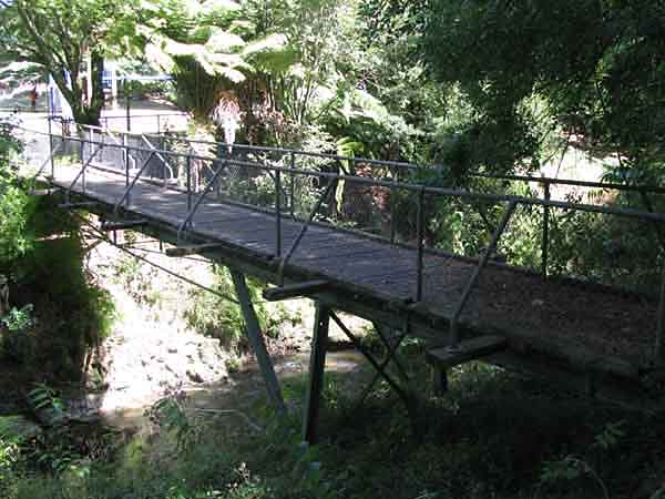
'Contact' The Last Rustic Footbridge Commemorating The Airforce
|
The Airforce footbridge was the last remaining of the original two identicle ‘Rustic’ footbridges built by volunteers under the supervision of Borough Engineer J. A Lee. Council should never have even considered removing and doing without this memorial bridge, essential to the parks layout and for access to the Picnic/playground area. It was repaired a number of times. The Navy footbridge beside the Mutu street traffic bridge, was originally of identical construction. Three footbridges were planned but there was a shortfall in donations.
See 20 Oct’ 52. F Parsons “Each of the footbridges…were to commemorate engagements in which our servicemen took part.”
See 3 Nov’ 52. Mayor F Parsons “Technical advisors tell me this will mean the abandonment of…one of the rustic bridges connecting the park with the picnic area”
The footbridges are essential to the park. See Mayor F Parsons 20 Oct’ 52. “The lay-out of the paths and in fact the general lay-out of the park must accord with the number of bridges.”
See 7 Nov’ 52. “The cost of each of the rustic footbridges was said to be 250 Pounds.”
See 16 Sep’ 53. “The approximate cost of each bridge will be 200 pounds.”
See Committee. 12 Oct’ 53. The footbridges were to be named after WW2 engagements, as per G A Gibbs ‘47 memorial plan.
See 14 Oct’ 53. Tramway rails were used as girders. Trusses were welded onto them.
Park designer Harrold Babbage: “The bridges would be in keeping with the general idea of the park. They would last for years and would require little maintenance.” Naming the footbridges was referred to the RSA via Mr Gower, who was assured; the park was in recognition of men who fell in WW2.
14 Dec’ 53. Mr Gower gave report of three names submitted from Te Awamutu's RSA service branches: Navy-‘Achilles’ Airforce-‘Contact’ Army-‘Kiwi’
By 21 July ‘54 the development of the picnic playground area north of the Mangaohoi donated by Austin Yarndley, was to optimistically: “commence with the erection of the three rustic bridges over the Mangahoe stream.”
However, only two rustic footbridges were present on opening day, Sunday 4 Dec 1955 due to funding.
Their names were not announced.
|
|
See Courier 5 Dec’ 55. Mayor C.F Jacobs: “Each of these bridges would be named by one of the services, the Navy, Airforce and Army”
Waikato Times 5 Dec’ 55 mis-reported that the dedication was to the “Airforce, Navy and Army” and “for services in the two World Wars.” However, the park is not for WW1, and there was no WW1 airforce.
Note: Courier Editor and Memorial Park Committee member Arthur Warburton would have been sure to get their stipulated dedication and the order correct.
14 March ‘56 At the last ever meeting of the Memorial Committee, held in the park as usual, their intention was to establish the third footbridge ASAP. Harold Babbage resigned but continued on with the Maintenance Committee. There were ongoing enquiries about funding and quotes.
In late Feb’ 58 there was a flood, bigger than the one in July ‘53 before the footbridges commenced. Both footbridges withstood the stream. Re-alignment of winding sections of the Mangahoe Stream followed, including re-alignment at the original site for Army footbridge.
The third ‘Army’ footbridge was finally built in ‘67-‘68 following a bequest from Marion Dawson of the Beautification Society.
It was not built the same as the Navy and Airforce footbridges and it did not last as long. Thus: the intended three commemorative footbridges were belatedly established, but without signage.
Was there T A Courier coverage of it's being installed?
Proposal for the Last Rustic Footbridge.
The trussed railway rails could have been replaced with stronger spanning H beams placed onto the existing foundations with the same wire net, pipe and tread board style, for the rustic footbridge to essentially remain the same. Plaques or signs would then be put onto the three footbridges commemorating their branch of the armed service:
C.F Jacobs 4.12.55 “the Navy Airforce and Army” “in recognition of their service and sacrifice.”
This would have left the last ‘Rustic Footbridge’ repaired and intact with its memorial concept complete.
|
Cross the 'Contact' Airforce Footbridge.
|
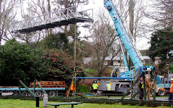
5.7.22 The Last Footbridge being dismantled with its replacement hoisted above.
|
Footbridge Design.
Gone are the Rustic Wooden Plank Treds, Grip-able Handrails and Wire Mesh Sidings.
See Left: The original Air Force footbridge being dismantled with its replacement being hoisted above it 5.7.22.
The Tramway Rails used as girders for the old footbridge are evident.
As the Army Footbridge is also to be replaced with a 'Shared with Bikes' width standard, it is preferable that the Shared Cycle-Way and Mobility Access Path approach the Air Force Footbridge from along the Stream-Side, over the existing flat access bridge. Not accross the Sunken Fernery.
Not unlike the Footbridges, The Sunken Fernery, is of Memorial Significance being one of Three Sunken Gardens that directly surround the Mound in which the Sunken Cross is Set, with its own triplets of Memorial Features.
Council has failed to recognise ‘Salient Memorial Features’ such as Sunken Gardens (in theme with the Sunken Cross) within the Memorial Design of the Park.
The Sunken Fernery and its Ornamental Stream is a result of Substantial Excavation in 1952-3.
Heritage Signs may soon tell The story of the Commemorative Footbridges.
The Air Force footbridge was dedicated to the service and sacrifice of Waipa District Air Force Servicemen and was allocated a name; 'Contact' in Dec' 53 by Te Awamutu RSA members of that branch.
Complete by Feb' 55 it stood for 67 Years. It was the last remaining of two identical 'Rustic' footbridges built by Lee Construction with volunteers.
Commemorative footbridges connecting shaded pathways amongst trees along the Mangahoe Stream were central to Geoff Gibbs 1947 proposal for a 'Park for a District WW2 Memorial' that was adopted and funded by the Waipa Districts.
The essential Picnic Area the footbridges lead to was donated by Austin Yarndley for that purpose.
|
|
The Scale Model of the Park.
The model was made by Harrold Babbage and G. A Gibbs and was put on public display in Mr R. K. Grieves’ shop window in Aug’-Sep’ 1951 to encourage donations. Diagram plans were also put on display in J.H Burns shop window.
See 27 Aug’ 51 and 15 Aug’ 51. Does anyone know of photographs taken of it?
|
|
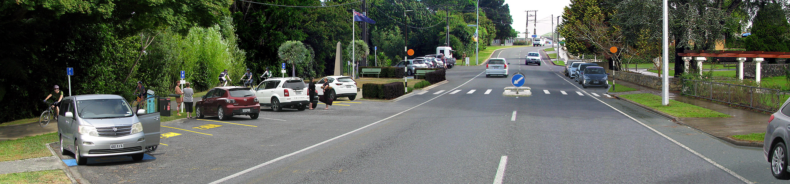
Congestion Relieving Two-Way Memorial Scenic Drive VS Congestion Inducing One-Way
|
|
The proposal to reduce the Scenic Drive-Way to Congestion Inducing One-Way, Limits Access and Egress.
The visitor experince would be hindered by being forced to exit in the wrong direction to congest a residential area requiring de-congestion
Concerning winter weekend Netball congestion: currently there are two roads in and two raods out. With a One-Way Scenic Drive, there are two roads in and only one road out. This increases exit traffic via the congested Mangahoe st.
Adding an additional enty/exit off Racecourse Road would then only result in a status quo for congestion.
The Scenic Drive-Way and its parking lot is essential for convenient access from within the park.
See 24 July 2018 Service Delivery Report page 44: Access to Park: Walk-45, Drive 145, Bike-8.
Most visitors by far use car access and many regularly just stay in the carpark for a short break.
See 20 Aug’ 51. Harrold Babbages Concept:
“Mr Babbage said that a driveway would be constructed…Along this and overlooking the park would be a parking lot where people could pull up and look out over the park or go down into it.”
From the viewpoint of the Scenic Drive-Way parking lot, the entire park can be apreciated as Sunken Garden, set within the flood plain of the Mangaohoi Stream.
See 4 Feb’ 52 and 3 March ’52 when the Scenic Drive-Way was formed.
See 24 March ’54 “Buses and heavy vehicles were prohibited from using it.” However, who would not prefer to retain Two Way access options for Emergency Services?
Bikes have always only been allowed on the road, but not in the park.
There was a chain bordered bike yard (originally pipe rail) at the bend in the road. The post of the bike yard sign still remains on the rocky knoll.
An Appropriate Concept for the 20kph Two-Way Memorial Scenic Drive:
Additional 20kph signs just prior to the bends either end of the Parking Lot.
Paint Centre Lines at the two bends.
Return the Bike Stand Yard (A chained off area at the bend in the road that could become a Re-Charging Depo
Drainage from the road greatly assists the Lake. See ‘The Ornamental Lake’ below.
The Scenic Drive has Three Drains that should all Empty into the Lake. In recent years only the Parking Lot Drain 2 was connected. Connect Drain 3 at the bend toward the Netball Courts to re-directed water into the Lake.
|
The Two-Way Scenic Drive could be named: ‘Babbage Way.’
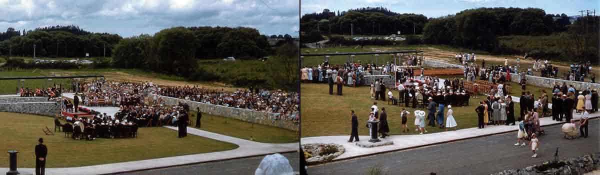
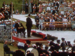
Mayor Jacobs: “The Park will stand as a living memorial to your citizenship.“
April 2020. The Scenic Drive-Way Car Park Entry
The Tea Kiosk was situated just in there.
|
Naming the Two-Way Scenic Drive: ‘Babbage Way’ and the end of Mutu St: ‘Anzac Parade.’ See Below.
Retaining and Naming the Two-Way Scenic Drive-Way to Acknowledge and Enhance the Heritage Values associated with the Formation and Dedication of our Artistic and Symbolic War Memorial Park.
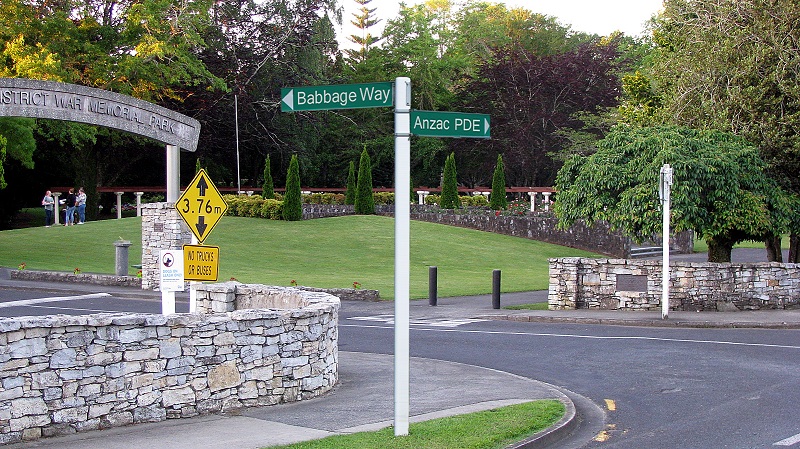
It would be appropriate to Name the Two-Way Scenic Drive-Way: ‘Babbage Way’ to Invite an Awareness of his Memorial Vision.
Harrold G Babbage was the designer, planner and supervisor of the parks construction.
30 May ’55. The park had been vested to the Council. “The ratepayers will...be proud to accept the responsibility of maintaining the memorial to sacrifice in a state worthy of those men and women who gave their lives.” “some clear policy should be evolved to ensure sufficient finance to maintain it”
Mr Babbage...has proved that he is a master of the situation. But what will happen if, and when, he resigns from this task? Is there any guarantee that a successor will be found who will...effectively cover all operations?
See 7 Nov’ 55 At the penultimate meeting of the Memorial Committee, Mr Babbage was to be their representive in the official party on opening day. However the record shows that the Mayor alone sufficed as Mr Babbage was to recieve accolades.
T'A' Courier 2 Dec' 55 “Mr Babbage had worked unceasingly and voluntarily and to him...must go the credit for the planning and layout of this park”
See opening ceremony accolades from Mayor C.F Jacobs and Prime Minister Sidney Holland:
T'A' Courier 5 Dec’ 55 Mayor Jacobs directly addressing Mr H.G Babbage: “One man had been responsible for the idea and supervision of the construction of the park, and that man was Mr H.G Babbage.”...“The Park will stand as a living memorial to your citizenship.”
PM Sidney Holland: “Mr Holland paid respects to Mr Babbage for presenting the design that had taken fruit in the park”
Waikato Times 5 Dec’ 55 “Mr Jacobs paid a tribute to the work done partly by enthusiasts, especially naming Mr Babbage for his leadership”
Prime Minister Sidney Holland: “Te Awamutu district had good cause to be proud of its beautiful war memorial, which would stand for all time as a remarkable one. He warmly congratulated Mr Babbage on his public spiritedness adding that an hour or two before the ceremony he had flown over Te Awamutu and had seen the memorial from the air at a low altitude-it was a beautiful piece of work.”
See 14 March ‘56 As he was moving to Auckland, Mr Babbage resigned from the War Memorial Committee and also resigned as Chairman of the Maintenance Committee to continue as a member.
Profound gratitude was expressed concerning “the park owing its existence to him to a very large degree”
Voluntary construction work, donations of materials and designing work carried out by Harold Babbage was valued at over 4,000 Pounds.
|
|
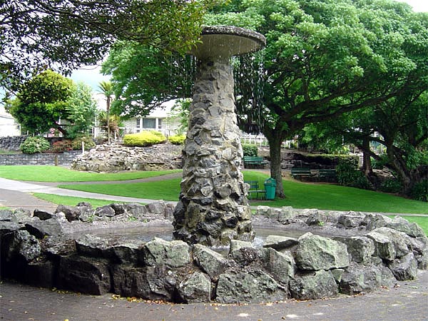
The Peace Fountain Plays on Armistice Day 11 November 2018.
|
The Peace Fountain. See Water Recycling Plan
One of a triad of Stone Built Monuments to Peace within the Memorial Complex.
The Historic Mural wall depicts our district’s history and our ‘Way of Life’ toward a Prosperous Future of Peace and Reconciliation. The Sunken Cross, referred to as the cross of memory, honours those who served, those who suffered and those who gave their lives for our country and our Way of Life, that we might have Peace.
The Peace Fountain symbolises that earned Peace, residing over a park made to provide and enable those qualities.
See George Warburton, Park Committee and Courier editor 30 May ’55: “The design and construction have been predominantly that of a scene of restful beauty surrounding a memorial to those who gave all that we might have peace and happiness.”
See 5 Dec’ 55: “Thus it can be reasoned that those who were prepared…to protect the freedom of the people are now, even in a memorial, continuing to serve and ensure comfort and peace.”
See 20 Aug’ 51. Harrold Babbage’s original concept involved a weeping fountain placed at the end of the Pergola. “a lovely thing” This is the shape it took. There is a small stone fountain just inside the fernery that weeps water from holes around its top.
See 28 Jan’ 55. After first: finishing the playground, the front stone wall, paving in front of the Sunken Cross, clearing ground and removing the Army Hut that was used for storage, the fountain was to finally be built in Nov’ 55, and would conclude the works programme of the Memorial Park.
See 11 May ‘55. “A fountain is to be built and the overflow from this will run into the large pond which will be filled sometime this winter from its own natural springs.”
But ground water within the excavated lake was insuffucient and it was filled via the paddling pools overflow.
See 2 Dec’ 55. The fountain was first turned on, Wednesday morning 30 Nov’ 1955, just four days before opening day, by Alf Smart who built the fountain that month. Water gushed up three feet initially and ran directly out to test the fountains emptying channels in the fernery, then being tidied by Alf Smart with collage pupils. The fountain was christened with an eel in its dish.
The fountain is 3.28 Metres high. Built in a weeping style, water is first collected in a bowl-platter and then falls. Photos from opening day and earlier show its plume to be 2 Metres high and cascading down.
|
|
The fountain’s perimeter stones differ in colour, texture and shape from the limestone and rock used throughout the park. Its stone pillar and perimeter depict the column and blast wave of an atomic detonation, making the fountain additionally significant as a memorial sculpture. It is possibly unique in the world as the only such WW2 memorial feature.
The opening day speech of Prime Minister Sidney Holland was in keeping with the post war hope for peace via nuclear deterrent:
Te Awamutu Courier 5 Dec’ 1955.
“Mr Holland spoke of the strength given to the western powers through possession of nuclear weapons, which he said, gave us great powers to stop wars.”
“We of the western powers have become stronger and we can now negotiate with strength behind us in our relations with other powers.” “Peace and freedom are not gained lightly.”
Waikato Times 5 Dec’ 1955 page 8.
“international affairs…were in a better position today because the western nations were stronger and therefore better able to negotiate for peaceable termination of disputes. Development of atomic weapons was an important factor”
|
|
In the 1950’s, Atomic Developments were popularised as great solutions for mankind.
WW2 ended due to the detonation of atomic bombs. This led to their association with peace. In post war Te Awamutu, people were well acquainted with atomic advances and issues.
See the Film ‘God of the Atom’ The colour film of war and atomic tests that screened at the town hall, 16 May ’51.
In June ‘54, The Mayor, executive officers and councillors attended an address on nuclear energy.
The Courier was frequently featuring articles on Atomic Developments, with headlines such as:
‘A Power for Peace’ ‘Peaceful use of Powerful Weapon’ ‘Peacetime uses of Atomic Energy’ ‘Atoms for Peace Plan’ ‘Use of Atoms against Floods’ ‘Atomic Revolution’ ‘Disarmament and H-Bombs’ ‘X-Ray Solution to Atomic Age’ ‘Peaceful Co-existence’ ‘NZ Atomic Energy. Co-operation Pledged for Peace’
‘Radioactive Atoms Work for Mankind’ ‘Atoms for Peace’ ‘Atomic Power for Inter-planet Travel’ ‘Nuclear Policy for Peaceful Disarmament’ ‘Advent of Nuclear Navy’ ‘Atomic Power for Peace’ Note The Theme.
An Appropriate Proposal for the Peace Fountain. There is ample space for a contemporary memorial for service and sacrifice subsequent to WW2 on Anzac Parade.
The fountain can easily function without costly ongoing technical issues, just as the Rose Garden’s fountain has for aprox’ 50 years. See Water Recycling Plan.
This is not a ‘significant challenge’ as was stated in the defunct Boffa Miskell draft plan.
The fountain’s dish holds 4.4 cubic Metres. Even if filled with town supply water, it would cost $ 7. If the fountain was run on weekends and holidays from 11am to 3pm with an immersed mains powered water pump, very little water would be lost to splash and evaporation, costing only cents per day.
However, if the fountain was instead filled and topped up with water from the fernery, it would not even have a daily cost.
A small top up pump in the fernery could run off a solar panel.
If the fountain's top up from the fernery was set to slowly overflow the fountain, its existing overflow outlet would again contribute to the lake, as was intended.
Community engagement and signage educating visitors on the price paid for peace could take the form of a plaque fixed to one of the fountains perimeter stones, acknowledging V’J’ Day, the end of WW2 and subsequent J Force conscription service of our drafted J Force soldiers of 1946-48 for their service in Japan.
|
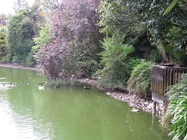
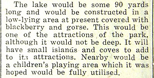
The Boating Lake.
Planned as a ‘Boating Lake’ it was later referred to as the 'Large Pond'. The small pond being the body of water between the Waterfall and the Stone Footbridge.
Low lying land covered in blackberry and gorse, was excavated to became an Ornamental Mud Bottomed Lake.
It too is a Sunken Garden, with plantings aound it and also within it on the Island.
See 3 March ’ 52. It was one of the first features of the park to be formed beginning in Feb’ 52. The area was deepened and Te Awamutu’s only island was made in it by piling rocks.
See 15 Aug’ 51. The lake was envisioned as a boating lake where people would go “to spend an hour or two beside a sheet of water in quiet and beautiful surroundings” as they do at Hamilton’s lake.
See Parks Report 12 Feb’ 69: Boating was finally realised with paddling boats hired from the Tea Kiosk by Mrs L.J D’Ath. See 16 Dec’ 69. Scouts hired canoes on holiday weekends.
See 11 May 55. Ducks and Swan were introduced into the lake. Along with resident frogs, Carp/goldfish, crayfish and eels were later plentiful. Lilly pads and oxygen weed were also plentiful.
“The driveway has yet to be sealed…A fountain is to be built and overflow from this will run into the large pond which will be filled sometime this winter from its own natural springs.”
However the lake did not fill by springs. There was boggy ground but no body of water. Excavation of the lake in '52 had exposed some ground water in its south side.
See 9 Nov’ 55 The lake was first filled with water in Nov’ 55 via the paddling pool's overflow. Children instead swam in the deep end of the lake with the frogs. ‘No swimming’ signs were then posted.
See 2 Dec’ 55 To remedy the mucking up from it being swam in, the lake was promptly refilled in time for opening day.
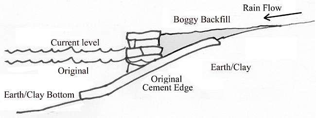
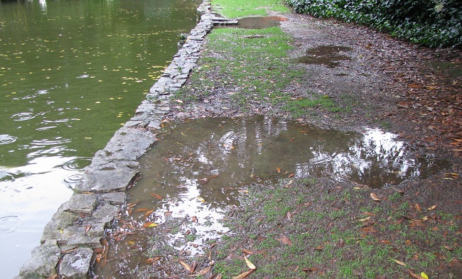
The perimeter was originally lined with a natural sloping cement edge. This enabled young ducks to get in and out. The current stacked limestone lake edge was built on top of that slope in 2001. The stone stacked edge prevents rainwater caught in it's backfill from entering the lake, causing boggy soil at the lake's edge. This has led to conjecture that the lake is leaking.
|
People miss the Tea Kiosk above the Waterfall Picnic area.
A Pop Up Weekend Cafe facility could be run from there.
The Tea Kiosk. c/o Stirling family collection.
|
All through the 2020 drought without the waterfall or the two jet fountains.
Only one of three road drains contributing for 19 years.
March 2020. Looks OK where there are stones lining the shore, during low water level.
|
The driveway was sealed aprox’ in late May ‘55. Its road drains also helped fill the lake as the fountain was not finished until 30 Nov 55. Road drains are now vital for refreshing the lake.
Road Drain 1 on the road bend. Completely blocked for years with no connection to the lake since aprox’ 2001 when the lake edge was relined. Reconnected by volunteers.
Road Drain 2 (delivering water from both sides of the car park) has been working.
Road Drain 3 (delivering water from both sides of the road) west of the car park, empties below the middle of three footpaths and has been washing out the lower river path for decades. Its outlet is only 18 metres from the lake edge.
There is ample evidence that the lake has been poorly managed.
Road drain 1 was cleared 20 March ‘20. It's input to the lake was then re-connected by volunteers. Rain can now significantly raise the lake level, with drain 2 in the par park also operating.
Drain 3 at the road bend towards the netball courts should now also be piped to the lake, after decades of washing out the lower river path.
The lake's ability to flush out depends on the height of the outlet pipe. The overflow spillway was originally an open channel and could again be ‘daylighted’
Many trees surrounding the lake make leaf fall into the water. A partly felled tree had been left in the lake since August 2017. (removed by a volunteer April ’20) This, and a tree stump at the base of the river bank nearest the N-W lake edge, causing water to scour the bank, was reported to councils manager of facilities at the 14 Aug’ 18 Community Board meeting. Such stumps had caused recent riverbank erosion adjacent to the netball courts and on Pioneer walk leading to expensive repairs. Assurance was given that the lake was not being managed toward a case to dispose of it. The stump in the stream bend near the lake remains.
Two jet fountains are in place in the lake for aeration. Prior to being fixed by volunteers, one had not functioned for a year, the other for three years, due to a break in its supply pipe. Soon after the repair on 11 Aug' 20, its nozzle was found sawn off. After fixing this, the other fountain was also got going by simply clearing a bolus of debris from under it's nozzle. These and the waterfall run off an electric pump supplied by an inlet pipe to the pump's reservoir. The inlet pipe is left high and dry when water levels drop, when it is needed most, like all through the summer of '19-'20 without waterfall or jet fountains and just one of three road drains contributing.
|
The Stone Stacked Edge Dams Surface Water flow
In the 2000’s a stacked stone edge was built onto the original cement slope shore at what was its waterline. The Paddling Pool was removed and the Waterfall’s Small Pond was reduced to 2/3 its size with much of its new edge built inside the original edge.
Areas around the lake are prone to saturated backfill from surface run-off being dammed against the cemented stone stack edge.
This led to a misunderstanding that the Mud Bottomed Lake is leaking.
|
Boggy Lake Edge. Rainwater Trapped Outsde Stacked Stone Edge
|
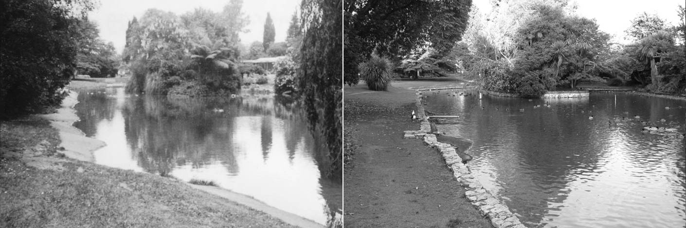
Lake Views along the original Noth Edge of the Ornamental Lake. 1979 is compared to May 2020.
Perspective alignment is proven via the Horizontal Elm eclipsing the stem of the peace fountain in both views.
|
The 2020 photo Above Right, shows the water level during drought when it was 30cm (1 foot) below the current spillway. Yet this was only 15cm lower than in 1979 as is evident with the exposed cement hump lake edge in the left foreground. This shows that the lake is now slightly smaller around its perimeter and is 15cm deeper than it originally was.
Note that the 'curve in' of the North West corner, seen in the '79 view, was extended outward toward the Stream.
Council's plan The lake is filled in, with alledged spring water somehow finding its way to the Mangaohoi Stream.
The Memorial Features of the Primary Picnic Area:
the Waterfall and it's Pond, the Stone Footbridge, The Stone Stairway, Trees, Paths and the Lakes Island; Gone!
Only a central portion of the lake would remain. A plan to remove the Primary Picnic area has not been made known to the public.
A drought combined with years of blocked road drains and neglected jet fountains should not have been followed with a resolve to remove the lake.
|
Original N/W Shoreline and Spillway Path ‘55.
|
Solutions For The Ornamental Lake. Within The Image:
Harold Babbages Vision for the Memorial ‘Boating Lake’ involved ‘Coves’ “to add to its attractions.” ‘Cove Features’ are here realized via Picnic Decks.
Three Picnic Decks provide Mutual Views of the Lake's Island and Supply Permanent Shade to reduce algae growth.
An 8 Meter section of Path and Stone Steps enable access down to the Southern Deck.
Views from the Parking Lot of the Memorial Lake and Features below. H Babbage: “where people could pull up and look out over the park, or go down into it.”
All Fan Palms have been removed. A Mix of Native and Exotic Trees are along the South Shore as per the Original Memorial Planting Plan.
A Third Jet Fountain is installed, branching off the existing east end line.
The N/W Footpath to the Spillway and the Original N/W Lake Edge are Re-instated with a Riparian Planted Sloped Edge along the entire North Side of the Lake, with a Pathway through it, connecting to the Airforce Footbridge.
The West End Road Drain is directed into the Lake to aproximately Double Current Water Catchment Input.
Wetland Bunds are planted at the West End, as per the Friends of Memorial Park 17 Dec’ 20 on site Protest Submission to WDC managers.
An Adjustable Spillway. The water level is Lowered, and then Raised, Prior to Expected Rainfall, to enable Rain Catchment Input to Accumulate with More Dilution.
The Spillway into the Stream is uncovered as it originally was, now with a section of Boardwalk over it.
A Microbubble Generator is installed to increase the water's Disolved Oxygen Level.
|
20.8.51
|
Scroll the Image Below L - R.
Options to Enhance Lake Water Quality and Biodiversity: The Quality of the Lake can be Improved. This is Not a ‘Significant or Expensive Challenge’.
Water entering the Stream via the Spillway is of an Improved Quality following a ‘Settling Pond’ Treatment. The Use Benefit of the Lake and Island is Enhanced.
Environment Management.
1. Three 7M X 7M Picnic Table Decks around the West Shore supply 150 Square Meters of Permanent Temperature Lowering Shade. They span out over the water from the 1.5M Widened Lake Side Footpath to reduce algea growth.
2. Removal of all Fan Palms and Leaf Dropping Trees along the South Side of the Lake. Leacheate from Compost Promotes Algae Growth.
Far Less expensive than reducing Lake size, The Ratio of Sun Exposed Surface Area / Depth-Volume is Reduced. The Three Decks enable ‘Cove’ Features envisaged by Harold Babbage for the ‘Boating Lake’ and provide Mutual Views of the Lakes Island.
3. Ruduced Duck Population. The Lake then functions as a Settling Pond for Road Drain delivered water that elswhere throughout town goes directly into the stream.
4. ‘Daylight’ the Piped Overflow Spillway into the Stream as it originally was and form a section of Boardwalk over it.
5. 5 yearly, Pre-Winter Emptying of the Lake for Maintenance using the Entry/Exit Ramp as was intended.
6. A Rustic Boardwalk Footbridge to the Island from the Playground end of the Lake, providing access to a Picnic Table on the East End of The Island Enhancing the Use Value of the Island Lake.
Water Catchment.
7. A Third Road Drain is connected to the N/W end of the lake. It traveres down from the road behind a 1 foot retaining wall, then under the footpath into the Lake.
8. Roof Water from Neigbouring Homes. Additional connections to further contribute to Catchment from the Scenic Drive.
9. A Ram Pump, requiring no electric power. Water from the Mangaohoi Stream can be pumped up into the lake during drought.
10. An Adjustable Overflow Level. The Overflow Outlet can be Lowered, and then Raised to full depth height, prior to expected rainfall, to allow a better dilution from rain catchment.
Water Treatment.
11. Three Water Aeration Jet fountains. With their Submerged Pump operating from within the Lake so as not to shut down should the water level drop.
12. A Separate Waterfall/Pump. submerged in the Lake to also supply the east end Jet Fountain. Increased Flow of the Waterfall will also Assist Aeration.
The Waterfall Channel input currently begins only half way along the Waterfall Course. It should begin further along at the top of the Raised Rockery. The Waterfall Course is very popular with children floating twigs down them etc.
The Water Course and Waterfall flow was mistaken for spring water in the council draft plan and also by folk reading their re-concept info’
13. A Micro-Bubble Generator to Raise the Disolved Oxygen Level. This along with Fountain Aeration promotes bacteria consumption of muck in the water. The existing on shore Reservoir, prior used for the fountain pump, can House the Mico-Bubble Generator. Power is Ready to go.
14. A Sand Filter that takes in the pre-waterfall supply, to then release filtered water.
15. Water treatments such as Muckbiotic Pellets that convert algea promoting lake sediment into Carbon Dioxide and H2O.
16. A Tethered Water Wheel Raft attached to the Wooden Footbridge 6. to induce a Slow Water Flow Around the Island to Counter Stagnation.
|
|
Entry Archways VS Many Gateways. Boffa Miskell: “Strengthening the connection between areas.“
By function or by title, Gateways do not “strengthen connection between areas” They restrict/demarcate from the wider community. Gateways planned for the Pergola entrance would confuse the memorial legacy.
From the outset, the park design envisaged the requirement of a road bridge connecting Mutu St with Ohaupo road. The bridge was finally in place by 21 April 1989.
See 20 Aug’ 51. The Original Concept: “As a route would be immediately past the park, their first impressions would be lasting.”
The Park, including the Entry Archway of 2002, is impressive to all who pass by, to or from that bridge.
The park’s Entry Arches embellish and strengthen the memorial design.
Gates were considered inappropriate for the Memorial Park.
See 20 Aug’ 51 “The Government has laid down that finance for war memorials must be for projects which are public in character, and the main feature of the park is that it is open to all sections of the public.”
15 June ’51 Prior to Harrold Babbage’s input: “It was generally agreed that gates be erected at the entrance”
25 July ‘51 After Harrold’s Concept Plan was adopted: “Memorial gates have been mentioned…as a memorial feature of the park, but I consider that gates are a failure” “The original scheme was simply to have gates to tell the people that they were entering a memorial park”
20 Aug’ 51 “Gates to the park had been eliminated as unnecessary” Instead the stone wall along Mutu st was suggested, with steel gates sliding inside the walls during the day. Only the stone wall eventuated.
20 Oct’ 52. Mayor Parsons: “A beautified, restful area, open at all times to all the people”
11 March ’53. “Mr Babbage reported that an offer had been received from engineers in town to make iron gates to be placed at the entrance to the park and the offer was accepted”
11 May ’55. “It was at one time intended to build a large memorial gateway to the park…lights are to be installed in preference” They too were not installed.
|
The Entry Archway. Not a Gateway.
Mayor F Parsons: "Open At All Times To All People"
|
Sundial with a View.
Enhancement of the Zion Sundal beside the Entry Arch on the Two-Way Scenic Drive-Way.
Set within the Ceremonial Area of Memorial Park, the Sundial Pedistal with its Bronze Disk is replaced.
The Sundial is accompanied by Three Bench Seats accessed by a path, to enhance the area around the Mound in which the Sunken Cross is set.
Additional Low Maintenance Shrubs are established along the inner edge of the Stone Wall.
See 25 July ’51. “A long range objective…development of the whole area from the racecourse to Albert Park for wide range public benefit…along the banks of the Mangahoi and Mangapiko streams almost limitless opportunity.”
See 20 Aug’ 51. Green Belt. “Looking further to the future…finally there would be a green belt right across…from the racecourse to Albert Park.”
Many of the current draft proposals to “provide opportunities for education and play grounded in ecology and culture,” could become developments in area’s at either end of the ‘Memorial Park as was proposed by G Gibbs.
Such as the picnic site opposite the squash courts and the area through Montefiore reserve from Te Wananga, to the Netball court area.
The proposed new car access from Racecourse Road would actually relieve congestion and improve car parking. Limiting the parks Scenic Driveway to a One-Way street will not. Educational signage and a gathering place at the Mangaohoi and Mangapikpo confluence, telling of the culture of Kaipaka Pa, would consolidate an historic cultural theme.
Kaipaka Park: A Heritage Culture Park.
The Mangapiko Stream originally wound its way toward the Mangahoe (as it was then spelt) to meet it head on at the present confluence. The final section of that original Mangapiko stream bed still exists, full of branches and leaves, surrounded in trees. That area beyond the entrance pictured, was part of what was Kaipaka Pa 1822-25. It was sold to Transpower in Sep' 21.
The area can now also be reached via 220 Racecourse Road as well as via the riverside bushwalk at 60 Racecourse Road.
As part of the original long term objective, it could be developed as an addition to the Pioneer Walk and become Kaipaka Park.
The Mangaohoi stream was also realigned at the netball end of the park some time prior to 1962.
A section between the three stream-side paths and the netball court, was straightened. The grass sloped end of the netball courts was the original ‘left bank’ of the Mangahoi stream. However, all current local maps, still show the streams original ‘Z’ shaped course.
|
Entry to Kaipaka Park off 60 Racecourse Road.
A Maori Culture extention of the Pioneer Walk.
Take a bush walk to Kaipaka Park
|
|
Puna Restoration
Just below the netball courts is a significant spring that could be developed without destruction, as is proposed for the Semi-Sunken Garden memorial feature.
Emerging from the slope below the netball courts is a spring outlet feature clad in limestone. It flowed immediately under a small stone slab footbridge (removed by council) The output is now piped under the path as if a nuisance, and heads off to enter the stream. All of the objectives for Puna restoration can be met here.
See Park reports of 1967. In this area was a Double Sided Picnic Shelter. It and the Army footbridge, were installed as late as 1968 via a bequest from Marion Dawson in 1966.
Alf Smart developed the area from 1965 onward with plantings and paths including a large boulder rockery beside the spring, donated by Mr C.H Douglas. This picnic area should still be benefiting winter netball attendees. Double sided picnic shelters as built by A.L Waters ltd could be rebuilt. It would be nice to see the small stone footbridge over the spring again.
|
|
The Lost Sunken Rose Garden.
The Sunken Rose Garden was destroyed in April 07 due to “ongoing maintenance problems”
Ironically, the flower bed that has resulted from the removal of the Sunken Rose Garden, takes up an inordinate amount of maintenance at the expense of the parks many memorial features.
See 24 March ’54. Stressed from inception: permanent materials, rock, concrete, paths and roadway would complete the park.
“It was not considered that the planting of flowerbeds or plots came within the scope of the construction of the park, whereas trees, shrubs, and lawns, which were of a permanent nature, did.”
Despite this maintenance concept, over attending to flower beds instead of the general upkeep of the park, continues.
5 April ’07. The destruction was referred to as a “significant upgrade for the garden” with new drainage, footpath and kerb. $42,000 was spent levelling it, rather than making repairs.
Within the Sunken Rose Garden were waterways that wound their way through around and under rockery features of steps, paths, seats, small footbridges, small pools, four rose beds and a sloped cactus plot.
Toward the entrance the water passed under the road, then through the rockery to the Sunken Lily pond, then on through the Sunken Fernery.
5 April ’07. Shirley Stirling: “It is a shame that the rockery and Sunken Rose Garden which was created through community efforts 52 years ago seems destined to be grassed over.”
”This project has been described as a restoration, but it sounds more like replacement to me”
Do not allow the same to happen to the rest of Our War Memorial Park.
At the entrance to the park on the curve of the stone wall is a bronze plaque.
“Built in proud and grateful memory of those men who served their country in the 1939-1945 War.
Opened by Sir Sidney Holland 4 December 1955.
Designed by H.G Babbage and G. Gibbs. Constructed by H.J Webber and A.E Smart.”
|
|
See the Sunken Cross’s Honour Roll
2 Dec’ 55. Arthur Warburton: “It is the result of the combined efforts of many public spirited citizens and a credit to us all. To view the project in retrospect may not bring back completely the task that these people set their hand to, but at least it will give the people some idea of the hopes, the fears and, indeed the accomplishments over a long period.”
See Published Contributors List.
5 Dec’ 55 Arthur Warburton. “Will the People in their turn be as faithful? Will they as this generation passes on, hand down the same spirit of service and sacrifice?”
Let this Submission also serve as a Heritage Assessment.
14.8.18 Anne McEwen. “I think that it would be a really good idea if council were to undertake a heritage assessment before they [whoever they are] decide to demolish or redevelop any council-owned asset of possible/likely historic interest.”
|
This Plaque Pertains to the Park, not to the Sunken Cross as indicated by Boffa-Miskell.
It should read 'Waipa District War Memorial Park' as planned, funded, built and dedicated.
I don't know when it was fitted. The Entry Arch of 2001 followed suit.
The Memorial Park was Vested to Council for Perpetual Maintenance in May 1955.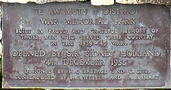
Should Boffa Miskel, Council’s Reserves and Biodiversity Planners and
Community Services Manager be named here instead?
|
THE BEST SENTIMENT COMES FROM THOSE WHO KNEW. Those who built the park, even with the next of kin in mind.
That is our heritage to cherish and value, not to remodel or re-concept.
God Save Our Memorial.
By what reasoning do Waipa Council’s Reserves Planners, Biodiversity Planner and Community Services Manager determine that: only the Sunken Cross, Front Wall and Scent Garden should be protected? Forsaking the very many obvious features of the memorial complex and the Planned, Built and Dedicated Concept of our Novel, Artistic and Symbolic War Memorial Park?
Marc Dawson.
acb3d@xtra.co.nz
I would like the opportunity to speak about this submission.
|
|